Items related to West Croydon and Selhurst 1911: Surrey Sheet 14.06...

Buy New
Learn more about this copy
US$ 3.59
Shipping:
US$ 38.65
From United Kingdom to U.S.A.
Top Search Results from the AbeBooks Marketplace
Stock Image
West Croydon and Selhurst 1911: Surrey Sheet 14.06 (Old Ordnance Survey Maps of Surrey)
Seller:
Rating
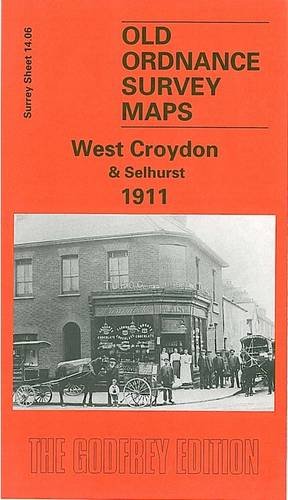
Book Description No Binding. Condition: New. No Jacket. Here are the details of maps for Croydon (N): Surrey Sheet 14.06 West Croydon & Selhurst 1911 - published 1998; intro by Oliver Harris. ISBN.978-0-85054-958-4 This map covers north Croydon and the area known, perhaps confusingly, as West Croydon, taking its name from the railway station. It covers an area stretching from Handcroft Road and Sumner Road eastward to Dartnell Road and Jesmond Road; and from West Croydon station northward to Selhurst station and Edith Road. Features on this busy map include numerous railway junctions (Norwood Fork Junction, Selhurst Junction, Windmill Bridge Junction, Gloucester Road Junction); Croydon Common Athletic Ground, home to Croydon Common FC and, for a while, Crystal Palace; Croydon Workhouse, Queens Road Cemetery, General Hospital, Croydon Union Infirmary; Addiscombe Road station. On the reverse are street directories for St James's Road, Sydenham Road, Whitehorse Road, Whitehorse Lane. The map links up with Surrey Sheet 14.02 Thornton Heath to the north, 14.05 Mitcham Road to the west, Woodside to the east, 14.10 Central Croydon to the south. Seller Inventory # 002648
Buy New
US$ 3.59
Convert currency